Karnischer Höhenweg
An 8-day trek over the main ridge of the Carnic Alps that forms the border between Austria and Italy. There are several variants and options to shorten the trek or make it more challenging. We did the most well-known form of the Karnischer Höhenweg, walking from Sillian to Hermagor in eight days.
Number of days: 8
Starting point: Sillian, Austria
End point: Hermagor, Austria
Difficulty: Difficult
Characteristic: Historic border line and hiking over mountain ridges
One of the finest hikes in the Alps
Heard from many fellow hikers that this is one of their finest hikes.
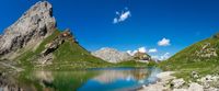
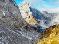
A hundred years ago, there was a fierce battle here during World War I and much of that can still be seen during the hike. Among other things, you will come across remnants of trenches and bunkers. In addition, the nature around you is also stunning. Because you spend almost the entire time on the mountain ridges, you have continuous 360° panoramic views! It alternates between peaceful alpine meadows to rocky terrain, dense forests, beautiful mountain lakes, some remaining snow fields and whole block fields. In addition, the occasional family of marmots passes by.
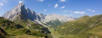
Contant sight on the steep peaks of the Dolomites
The first part of the hike is along the Friedenswegs. This path was built along the Austrian-Italian front line from World War I.
The trek crosses many mountain ridges where you constantly see the steep peaks of the Dolomites on the right.
Tough hike, but accessible to everyone
The trek is indicated as a very tough one and is known as the trek where most shoes get killed. This is mainly because it has a very alpine character with a lot of rough terrain. In contrast, there is a lot of variation between mountain ridges with spectacular views and alpine meadows and stretches of forest. There is also a choice each day between an additional summit, the ridge route or a route below. So, in my opinion, the route is accessible to everyone, especially when I look at ourselves; two 18-year-old girls without any experience, though with a very sporty background.
Well equipped huts
The huts along the Karnischer Höhenweg are well equipped. In the evening, there are no elaborate menus, but a 3-course dinner is served. Some huts like the Filmoorhütte do not have showers available.
Book the huts a few months in advance!
That is definitely recommended for the high season! We had booked the huts a few months in advance.
What is the suitable period?
The huts are open from mid-June to September. There is more chance of snow and winter conditions at the beginning and end of the season.
How to get to the starting point?
The nearest airport is Innsbruck. From there, it's another 2.5 hours by train to Sillian.

Day program
Day 1: Sillian→ Sillianer Hütte
6.5 hours; 13.5km; 1370m ascent; 0m descent
We started our route in Sillian, where we travelled by night train from the Netherlands. It is also possible to go up by cable car from Viersach, but we chose to walk up the 1400m ourselves. A few times we briefly regretted this, but all in all it was a beautiful stage through the forests and across the alpine meadows. At night we slept in the Sillianer hütte, here we were momentarily shocked by the meals provided and feared we would be starving this hike. Fortunately, this was the only hut that handled meals so commercially.
Day 2: Sillianer Hütte → Filmoorhütte
6.5 hours; 13.6km; 850m ascent; 950m descent
The second day started with a beautiful sunrise, but soon became a bit more dangerous. We had to cross a kind of 'little bridge', a ladder with mesh and filled with some large stones above a ravine. This took some swallowing, but fortunately we did not experience anything like this again for the rest of the trip. We had a delicious lunch of eggs and fresh milk from the cow at the Obstanserseehütte. After this, we walked on to the Filmoorhütte, where the sociable man was already waiting for us with cans of beer.
Day 3: Filmoorhütte → Porzehütte
3 hours; 6.3km; 220m ascent; 630m descent
The next day was a bit our 'rest day', we planned a stage to the Porzehütte of about 3 hours to recover from the first few days. This was a beautiful stage over the green alpine meadows.
Day 4: Porzehütte → Hochweißsteinhaus
8 hours; 17.3km; 1030m ascent; 1100m descent
The 4th stage is also known as the Köningsetappe! A very long hike with lots of altimeters, but very rewarding! During the crest hike, there were continuously only high peaks around us. Some parts were secured with steel wire, which we found quite scary and intense at times. So we arrived at the Hochweiβsteinhaus really exhausted. Here is the option to stay an extra night and climb the Hochweiβstein.
Day 5: Hochweißsteinhaus → Wolayerseehütte
7.5 hours; 14.3km; 1070m ascent; 980m descent
This day we leave the mountain ridges a bit and enter the lower Italian alms towards the Wolayerseehütte. This hut has a beautiful location, so it is really enjoyable on the terrace.
Many hikers walk from the Wolayerseehütte to Kötschach the next day and end their trek there.
Day 6-8: Interrupted by severe weather
That night, unfortunately, the weather completely turns and it storms and thunders violently. After some asking around, we are advised the next day to walk towards the valley and continue our route from there instead of the 8-hour trek up the ridge. We therefore walked to the Plöckner Pass and hiked from there to the village of Kötschach. This was another stage where for many people their trek ended and we said goodbye to each other.
After spending the night in this village, the next day we took the bus to Tröpolach and then took the cable car up. From there, we resumed our trek back to the Alpenhotel in Naβfeld.
This was already the last day of our Karnischer Höhenweg. We continued our way towards the valley to Hermagor via the magnificent Garnitzenklamm.
This is also the big advantage of this tour; from every hut there is a way back to the valley in case of unexpected circumstances such as bad weather or illness.
The route can be extended by 3 extra days up to Unterthörl.