Venediger Höhenweg
A 6-day hut-to-hut loop through the Venediger Group in the Hohe Tauern National Park, East Tyrol. It's a demanding trek. But it rewards you with jaw-dropping views of glaciers, high alpine lakes, and the Grossvenediger, Austria's second-highest mountain. Over the six days we covered close to 78 km and climbed more than 5,400 vertical metres in total.
This 6-day route is only for experienced mountain hikers with some hut-to-hut trekking under their belt. It is definitely not a suitable trek as your first hut tour. Almost all stages follow red or black mountain trails, with technical sections secured by steel cables and long stretches over boulders and scree. No special climbing gear is needed, just sturdy hiking boots and poles, but expect to use your hands on a few sections. Old snow can linger well into summer, which sometimes makes route-finding trickier. Camping is strictly forbidden inside the national park, so it's huts all the way.
Number of days: 6
Starting point: Matrei i.o., Austria
End point: Matrei i.o., Austria
Difficulty: Moderate/hard
Distinctive feature: Glaciers, high passes, and a full circuit around the Grossvenediger
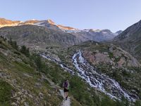
Highlight: Neue Prager Hütte and its glaciers
The highlight of this trek is the overnight stay at the Neue Prager Hütte (2,798 m). It's one of the highest and most dramatically situated huts on the route, with the glaciated flanks of the Venediger massif right on your doorstep. The stage that follows is just as memorable. The trail runs along the so-called Gletscherweg (glacier path) toward the Salzbodensee, with huge glaciers, locally called "Kees," lining the route almost the entire way.
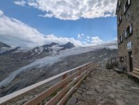
Be well prepared every morning
Carry enough clothing for all weather conditions. Mountain weather can change quickly, and this trek crosses high passes with little to no option of descending into the valley during bad weather. Several passages are secured with steel cables, so sure-footedness is a must. Ask the hut warden each evening about the forecast and trail conditions before setting off.
Book the huts early!
The Venediger Höhenweg is a popular route, so book your huts well in advance. Most reservations can be made easily via the online systems of the huts.
We started from a hotel in Kitzbühel and took the bus to Matrei i.o., getting off at the toll gates close to the Matreier Tauernhaus that mark the entrance to the trailhead. Ask the busdriver to drop you off, as it is not an official bus stop. From the toll gates, the trek begins on foot into the Tauerntal valley.
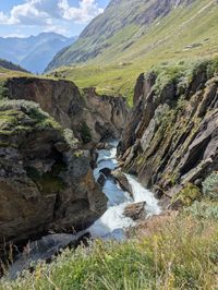
Day programme
Day 1: Matreier Tauernhaus → Sankt Pöltner Hütte (2,481 m)
5 hours, 9,6 km, +1,047 m, 🟥
After the bus from Kitzbühel dropped us off at the Matreier Tauernhaus toll gates, we headed straight into the Tauerntal valley. The trail climbs through ancient larch forest, with visible glacial striations in the rock from the last ice age. It works its way up toward the Tauernkogel massif. Sankt Pöltner Hütte sits right on a high saddle, with power lines from the Tauern crossing running overhead.
Day 2: Sankt Pöltner Hütte → Neue Prager Hütte (2,798 m)
9 hours, 16,2 km, +1,064 m, ⬛
A long, demanding day. The route follows the St. Pöltner Westweg onto the Venediger Höhenweg proper, crossing high, rocky terrain below the Innerer Knorrkogel and Weißspitze. The glaciated peaks of the Venediger group stay in view almost the entire way. As we approached, the Neue Prager Hütte revealed itself right at the edge of the ice, easily one of the most spectacular hut locations of the whole route.
Day 3: Neue Prager Hütte → Badener Hütte (2,608 m)
7 hours, 11,6 km, +811 m, ⬛
Via the Alte Prager Hütte and the Unterer Keesboden, the trail joins the Gletscherweg toward the Salzbodensee (2,137 m), a small alpine lake fed by meltwater. From there it climbs to the Löbbentörl (2,770 m), the highest and most dramatic pass on this stage. This last climb is genuinely technical and exposed, with long stretches of steel cable along a narrow rock ledge, at one point passing right under an overhanging cliff with a waterfall spilling from the Kristallwandkees glacier above. It demands real focus and sure-footedness, but it's absolutely doable. At the top, a small memorial cross marks the spot locals call the "Eye of God," with an unforgettable view over the Schlatenkees glacier below. From here it's a gentler descent to the Badener Hütte.
Day 4: Badener Hütte → via Bonn-Matreier Hütte → Eisseehütte (2,500 m)
9 hours total (Bonn-Matreier Hütte after 6 hrs), 18,2 km, +1,271 m, 🟥
The longest and toughest day of the trek. First a rugged, high-alpine crossing over two passes, the Galtenscharte (2,871 m) and the Kälberscharte (2,791 m). Both are technical and exposed, only sensible in snow-free, good conditions. After around 6 hours we reached the Bonn-Matreier Hütte, a good spot to stop for lunch and refuel before the final push. From there the trail continues over the Eselsrücken and around the Wunspitze, passing below the Hoher Eichham and Grosser Hexenkopf, down to the small glacial lake beside which the Eisseehütte is built. Keep an eye out for edelweiss along this last stretch, it grows in patches near the hut.
Day 5: Eisseehütte → via Johannishütte → Essener- und Rostocker Hütte (2,208 m)
9 hours total (Johannishütte after 3u30), 15,5 km, +1,212 m, 🟥
Another exposed, high-alpine day. The route climbs steeply, partly rope-secured, over loose scree to the Zopetscharte (2,958 m), the highest point of the entire Venediger Höhenweg. From there you descend to the Johannishütte (2,121 m), reached after about 3,5 hours. It's the oldest mountain hut in the Eastern Alps and a good place to sit down for lunch before the final climb. From there we went over the Türmljoch (2,790 m) and down to the Essener- und Rostocker Hütte.
Day 6: Essener- und Rostocker Hütte → Ströden
2 hours, 6,4 km, +12 m, 🟦
A short, easy final descent through the Maurertal valley back down to Ströden. From there we caught the bus to Matrei and from there the bus to Kitzbuhel and in the evening the night train back home.
 English
 Nederlands