China - Yubeng
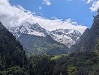
A hidden gem in the shadow of Meili Snow Mountain! This 4-day trek takes you into Yubeng, a Tibetan village so remote it can only be reached on foot, tucked away in a valley at the foot of Kawagebo (6740m), the highest and most sacred peak of Yunnan. You walk through dense pine forest, past fluttering prayer flags, to a glacial lake fed straight from the ice above and to a waterfall considered holy by local Tibetans. Yubeng consists of two villages; Upper Yubeng and Lower Yubeng.
Because Yubeng has no road access, the pace here is slow and the village itself feels like stepping back in time. When we arrived in May 2026, this was sadly about to change. They were building a road from Xidang to Upper Yubeng, so in a while you can take a drive to the villages. Then Yubeng is way easier to reach, so expect more tourism and less quietness.
Number of days: 3 or 4
Starting point: Ninong (or Xidang, when the road is open)
Ending point: Ninong (or Xidang, when the road is open)
Difficulty: Moderately heavy
Distinctive feature: A remote Tibetan village beneath a sacred, snowcovered mountainpeaks
What is the character of the trek?
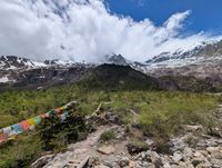
Thick pine and rhododendron forest gives way to alpine meadows and, higher up, bare rock and glacier ice. Upper and Lower Yubeng Village themselves are full of Tibetan Buddhist culture: small monasteries, prayer flags, and stupas mark the trails in every direction.
What are the highlights of the trek?
The two standout days are the hike to the Glacial Lake, an emerald pool fed directly by the glaciers of Kawagebo, and the hike to the Sacred Waterfall, where Tibetan pilgrims bathe in the falls for spiritual purification. Arriving in Upper Yubeng itself, with Kawagebo's snowy summit rising directly behind the village, is a highlight in its own right.
How difficult is the trek?
This is a moderately heavy trek with real elevation gain, particularly on the walk in and on the day to the Glacial Lake, which climbs to around 3,900 metres. The paths themselves are well maintained and require no technical skill, just decent fitness and sturdy legs.
Upper Yubeng is at 3,00 metres and the day trails climb to around 3,00 metres, so altitude can be a factor. If you come from Lijiang and Shangri-La, you will probably be quite climatised. Take it easy, drink plenty of water and eat enough. Read our blog for tips how to prevent and deal with altitude sickness.
How to arrange the trek to Yubeng?
You can walk the main trails without a guide; they're clearly marked and busy enough that you'll rarely be alone. For accommodation and meals you don't need any help at all: Upper and Lower Yubeng both have guesthouses that are simple to book on arrival, though it's worth noting that prices for food and snacks are higher here than elsewhere, since everything has to be carried in.
We recommend staying in Upper Yubeng. From here you have the best views and here starts the trail to the Glacial Lake.
What is the best time to go?
The best months are May and June, when temperatures are mild and wildflowers are in bloom. July and August bring the rainy season, with muddy trails and a higher risk of rockfall. Trekking is not recommended between February and April, due to heavy snowfall, freezing temperatures, and avalanche risk.
How do you get to the starting point?
Most trekkers start from Shangri-La, travelling via Deqin to Feilaisi. Book your bus tickets to Feilaisi a few days in advance at the bus station in Shangri-La. The drive takes about 4 hours and the bus will have a short stop at a viewpoint.
It’s recommended to stay the night in Feilaisi and enjoy the sunrise in the morning over the Meili Snow Mountain. Tip: if you arrive on time in Feilaisi the day before, take a cab to the Mingyong Glacier. An hour drive followed by a 3-4 hour hike on stairs to see this amazing glacier.
From Feilaisi, a shared van or cab takes you to the trailhead, either Xidang or Ninong depending on which road is currently open, from where the trek into the valley begins on foot. When we visited the road from Xidang was closed, so we started the hike from Ninong and that was a great hike next to a wild river.
Day programme – 4-day trek
Day 1: Ninong → Upper Yubeng
15 km, 5-6 hours
The trek begins with a steady, at times steep, climb out of the valley, gaining around 1,000 metres in elevation. It can be quite hot in the gorge, so take plenty of water with you or buy some drinks along the way and take it easy. First you reach Lower Yubeng, from there it is another 45 minutes with 250 metres in elevation to Upper Village.
Day 2: Upper Yubeng → Glacial Lake → Upper Yubeng
13 km, 6-7 hours (round trip)
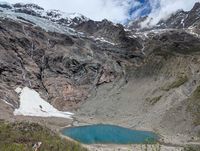
Today is a there-and-back hike to the Glacial Lake at around 3,900 metres. The trail climbs steadily through pine forest to Xiaonong Base Camp, once used by a mountaineering expedition, and then continues upward through increasingly rocky, alpine terrain. The lake itself sits directly beneath the glaciers of Kawagebo, its water an intense emerald green, with slabs of ice sometimes visible at the edges. After taking it in, you return by the same path to Upper Yubeng.
3-day trek: It is possible to stay the second night in Lower Yubeng, because the trail to the Sacred Waterfall starts from there and then you can hike down back to Ninong from here and make it a 3-day trek.
Day 3: Upper Yubeng → Sacred Waterfall → Upper Yubeng
15 km, 4-5 hours (round trip)
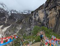
Another out-and-back day, this time to the Sacred Waterfall at around 3,650 metres. The trail starts in Lower Yubeng and passes through forest strung with prayer flags and by a small Tibetan Buddhist temple before opening onto the valley leading to the falls. Local pilgrims often walk three circuits around the waterfall and bathe beneath it for spiritual purification. Expect the trail to be a little muddy near the falls. In the afternoon you return the same way to Upper Yubeng for your last night in the village or you stay in Lower Yubeng before you hike down again.
Day 4: Upper Yubeng → Lower Yubeng → Ninong
15 km, 5-6 hours
The final day retraces your route out of the valley, descending through Lower Yubeng Village and then down toward the trailhead. If you came in via Ninong, this route follows a narrower trail along the river, passing a side waterfall and finishing with a stretch reminiscent of a miniature Tiger Leaping Gorge; it's mostly downhill and considerably easier than the walk in. From the trailhead, arrange a car back to Feilaisi or Shangri-La to complete the trip. You can also take a cab to Deqin and take the bus back to Shangri-La. Lots of drivers are waiting for you at the trail end.
 English
 Nederlands