Berliner Huttentour
This is a demanding trekking route with breathtaking views of glaciers, mountain lakes, alpine meadows, and picturesque huts.
This 8-day trek is only suitable for experienced hikers with previous hut-to-hut trekking experience. It is not a good choice as your very first hut-to-hut hike! Almost all stages follow black alpine trails with many technical sections, steel cables, and massive boulders.
You don’t need to walk the full 8 days—each stage can be shortened at any hut, making it easy to adjust the trek to your own preferences.
- Duration: 8 days (easily shortened if desired)
- Start point: Mayrhofen, Austria
- End point: Mayrhofen, Austria
- Difficulty: Hard
- Terrain: Boulders and lots of elevation gain

Highlight: Schönbichler Horn at 3,134 m
The highlight of this trek is the stunning 360° panorama from the Schönbichler Horn (3,134 m) on day 5—glaciers, mountain lakes, and sharp peaks all around. You’ll also often hike across lush alpine meadows with glaciers gleaming in the background.
Limited warm showers along the route
The huts on this tour are all well-equipped with dormitories, double rooms, and beautiful views. However, warm showers are limited. Only the Berliner Hütte, Furtschaglhaus, and Friesenberghaus have hot showers. In the other huts, you’ll need to make do with cold outdoor showers or washbasins.
Be well prepared every morning
It’s essential to carry enough clothing for all weather conditions. Mountain weather can change rapidly, and this trek crosses high passes with little to no option of descending into the valley during bad weather. Always ask the hut warden each evening about the forecast and trail conditions. Some stages are impossible in poor weather—in such cases, you’ll need to descend into the valley and continue to the next hut from there.
Book huts early!
The Berliner Hut Tour is extremely popular, so book early—ideally in January for the summer season. Reservations can be made easily through the huts’ websites.
The start/finish point Mayrhofen is easily accessible by both public transport and car. You can take the night train to Jenbach and then continue by bus or train (both about 1 hour) to Mayrhofen. If you fly, the best airports are Innsbruck or Munich. From there, take the train to Jenbach and continue with bus or train to Mayrhofen.

Day-by-day itinerary
Day 1: Mayrhofen → Karl von Edelhütte
5.5 hrs, 9 km, +1600 m / –0 m, 🟥
A tough first day, climbing steadily through forested paths. Midway you pass the Alpenrose, where you can rest on the terrace.
Alternatively, you can skip the ascent by taking the Ahornbahn cable car from Mayrhofen to the mountain station, from where it’s a 30-min walk to the hut. From there, you can also climb the Ahornspitze—a challenging but rewarding option.
Day 2: Karl von Edelhütte → Kasseler Hütte
9 hrs, 14 km, +900 m / –900 m, ⬛
A very demanding day, only possible in good weather. In wet conditions, take a lower valley trail instead.
The route crosses countless ridges, with sections requiring you to find your way across and over large boulders.
Day 3: Kasseler Hütte → Greizer Hütte
6 hrs, 11 km, +900 m / –900 m, ⬛
The day begins with a suspension bridge just after the hut, then several stream crossings. In wet conditions, these may take longer. Afterward, a steep climb with steel cables leads to the Lappenscharte (2,700 m). From there, a gentler descent brings you to the hut.
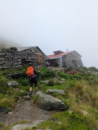
Day 4: Greizer Hütte → Berliner Hütte
7 hrs, 13 km, +1100 m / –1000 m, ⬛
Challenging but beautiful, ending at the iconic Berliner Hütte. The morning starts with a big descent, followed by a steep technical climb with steel cables and even ladders—not for those with fear of heights! You’ll see the Berliner Hütte from afar, but the descent to it is still long.
Day 5: Berliner Hütte → Furtschaglhaus
6 hrs, 10 km, +1200 m / –1000 m, ⬛
Today’s highlight is the climb to the Schönbichler Horn (3,134 m). A tough day with many meters of ascent. The final ridge is narrow and exposed on both sides but secured with steel cables—take your time. The panoramic glacier views from the top are unforgettable.

Day 6: Furtschaglhaus → Friesenberghaus
6 hrs, 16 km, +900 m / –1000 m, 🟥
A relatively easier day. After a short descent, you walk 5 km on a flat trail along the reservoir, with several cafés to stop for a drink. Halfway, the trail climbs easily up to the Olpererhütte (a popular overnight alternative). From there, it’s a 2-hour walk on a good trail to the Friesenberghaus, with views of the lake and glaciers above.
Day 7: Friesenberghaus → Gamshütte
9 hrs, 19 km, +1100 m / –1000 m, ⬛
Another very tough stage! A long day with tricky trails and many boulders. In wet weather, it can be especially difficult. There are 3 possible exit routes into the valley if necessary. In the Gamshütte, celebrate the trek with Kaiserschmarrn or their famous cheesecake!
Day 8: Gamshütte → Mayrhofen
3.5 hrs, 11 km, +0 m / –1200 m, 🟥
A steady descent through forest trails to Finkenberg. From there, either take public transport back to Mayrhofen or continue on foot for 1.5 hrs to return to the starting point.